

Easy Sunday: The 100th Meridian

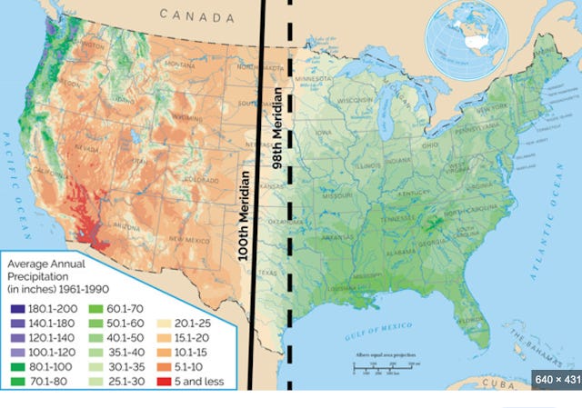
The 100th Meridian divides America.
(Actually it is the 98th Meridian, but 100 is a round number, and in 1878 John Wesley Powell said the 100th was the divide, and that has stuck.)
Here is a map of the night-time sky of the U.S. It shows the people and economic activity happening in a place, so it combines population and industrial activity.
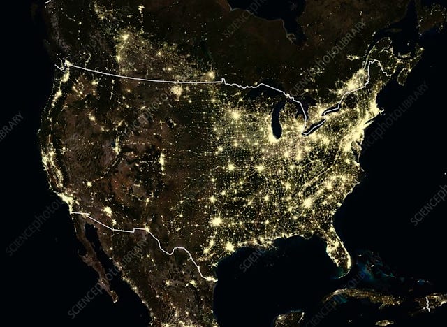
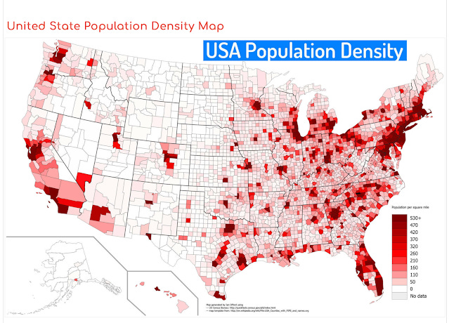
It is very similar to a map of population density. The West has densely populated cities surrounded by ranch-land except where irrigation is available. The noteworthy difference between the maps is the bright spot in western North Dakota, where oil and gas production light up the night sky.
Much of the west is arid, caused in part by three mountain ranges intercepting moisture generated over the Pacific Ocean. The continental climate of the East gets humidity off the Atlantic in the winter, but the moisture only extends to mid-continent. The moisture off the Gulf curves to the east, again leaving the West dry. East of the 98th Meridian people can grow corn. West of the line people can grow wheat in some places. Corn produces 12 million calories of food energy per acre. Wheat grows at most six million calories per acre. East of the line agriculture is productive using natural rainfall. West of the line, almost everybody needs irrigation.
Pioneers trekked their way 2,000 miles from Independence, Missouri to bypass all that semi-arid land to get to Oregon's Willamette Valley. Western Oregon and Washington have rainfall from moisture from the Pacific dropped into the valleys west of the Cascades.
The relationship between rainfall and population density made intuitive sense back when the primary occupation of Americans was agriculture, but the maps show the pattern persists. The bright spots of population density in the West are places with water, either from rainfall in the Northwest or from irrigation projects, primarily from the Colorado River and from water moved from Northern California into the California Central Valley.
People live where there is water.
"People live where there is water."
Yes.
But it's more than mere rainfall. The annual total rainfall in Cairo is 18 mm--0.7 inches. Annually.
But rainfall (and a bit of snowfall) far away allowed people to build a great civilization. Ditto other places in the Americas, Asia, and Europe. Rivers carried water, energy, nutrients (both directions), silt topsoil, and provided transportation for us and our cargo.
Add a river to an ocean, and a port city--or port cities--will likely evolve.
A geologist who grew up on the Columbia told me that when he first saw the Danube, his first impression was, "What a sad, nasty, little ditch!"
But oh, the empires!
Nicely said Peter...So what are you really saying? Would most of the rest of us out of the rainbelt be mostly screwed???